
Real Estate Aerial and Drone Photography Services in Kendallville: Showcasing Properties from a Captivating Perspective
In the dynamic world of real estate, captivating visuals play a pivotal role in attracting potential buyers and showcasing properties effectively. Our Professional drone real estate photography services in Kendallville, encompass various aspects, including listing photos, virtual tours, and aerial photography. By leveraging these powerful visual tools, real estate professionals can create a compelling narrative around properties, enticing buyers and leaving a lasting impression.
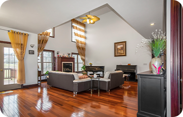
Listing Photos: Making Lasting First Impression
Listing photos are the first point of contact for potential buyers, making them crucial in capturing their attention and generating interest. Our Professional Real Estate Drone & Aerial Photographer in Kendallville employ their expertise to highlight the property's key features, ensuring that each photo reflects the property's unique appeal. Through the skilled use of lighting, composition, and staging, listing photos showcase the property's best attributes, creating an emotional connection with potential buyers.
Virtual Tours: Immersive Experiences for Remote Viewings
Our Real Estate Virtual Tour Services in Kendallville allows potential buyers to explore real estate properties remotely, providing a comprehensive view of the layout, flow, and design. Virtual tours can be interactive, enabling viewers to navigate through rooms, zoom in on details, and get a realistic sense of the property's ambiance. By providing an engaging and interactive experience, virtual tours enhance buyer engagement and help them envision themselves in the space.
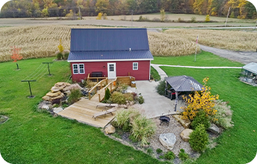
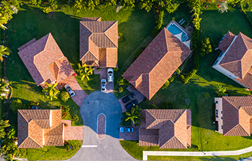
Aerial Photography: Showcasing Properties from New Heights
Our Real Estate Aerial Photography Services in Kendallville offers a unique perspective that traditional ground-level real estate photography cannot replicate. By capturing stunning images from an elevated viewpoint, aerial photography provides an expansive view of the real estate property and its surroundings. It highlights features such as the property's location, nearby amenities, and natural surroundings, giving potential buyers a better understanding of the property's context. Real Estate Aerial photography is especially effective for showcasing large estates, waterfront properties, or properties with extensive grounds.

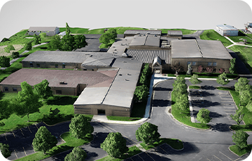
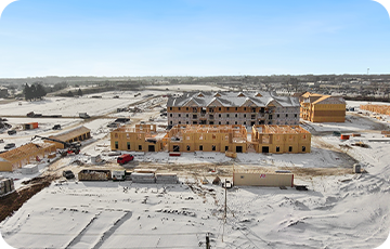
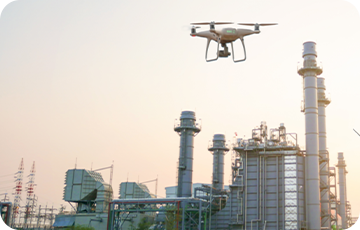
Aerial Insights for Construction: Transform Your Projects with our Drone Photography Services in Kendallville
In addition to real estate, our drone photography services extend to the construction industry. Drone photography for construction offers invaluable benefits in documenting construction progress, conducting site surveys, and capturing aerial footage for marketing purposes. From construction site aerial photography to drone photography for construction inspections, we provide comprehensive and accurate visual documentation that enhances construction project management and communication.
As an aerial and drone photographer in Kendallville, Indiana, we cater to the unique needs of the local real estate and construction markets. We understand the nuances of the Kendallville area and employ our expertise in aerial and drone photography to capture stunning visuals that resonate with your target audience.
Whether you require aerial photography for real estate, drone photography for construction, or both, our skilled team of photographers and drone pilots in Kendallville is equipped with the latest equipment and techniques to deliver exceptional results. We pride ourselves on our attention to detail, professionalism, and commitment to exceeding client expectations.
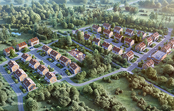
Professional Aerial Survey and Drone Mapping Services in Kendallville:
-
Orthomosaics
Our professional aerial survey and drone mapping services in Kendallville offer comprehensive solutions for generating high-resolution orthomosaics that can be used for a wide range of applications such as land surveying, urban planning, environmental monitoring, and more. By utilizing advanced drone technology and state-of-the-art image processing techniques, we capture aerial imagery of large areas with exceptional detail and accuracy.
-
NDVI Plant Health
NDVI measures the health and vigor of vegetation by analyzing the reflectance of near-infrared and visible light. By capturing multispectral imagery with our drones and applying sophisticated algorithms, we generate NDVI maps that depict the relative vegetation health across an area of interest. These maps help farmers, environmentalists, and land managers assess crop health, identify areas of stress, detect disease outbreaks, optimize irrigation, and make informed decisions regarding vegetation management.
-
Elevation maps
Our drone-based elevation mapping services offer accurate and detailed terrain models for various applications. These elevation maps provide valuable information about the topography, slope, and elevation changes of the Kendallville area. They are essential for urban planning, flood risk assessment, infrastructure development, and environmental analysis. Our experienced drone/aerial photographer in Kendallville ensures reliable data collection, processing, and interpretation, enabling you to make informed decisions based on accurate and up-to-date elevation information.